
Wisconsin urban bike maps
The Wisconsin Department of Transportation (WisDOT) is developing urban bike maps for Wisconsin municipalities with populations greater than 25,000. These new maps are a complement to the Wisconsin state bike map, which provides bicycling conditions for rural state and county highways.
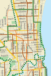
The urban bike maps provide information about:
- The traffic volume (low, moderate, high) of major urban streets
- The location of wide outside lanes on major urban streets
- Bike trails/paths
- Signed bike routes
- Designated bike lanes
WisDOT urban bike maps (Maps are best printed at 11" x 17")
- Beloit
- Eau Claire/Chippewa Falls
- Fond du Lac
- Janesville
- Kenosha
- La Crosse
- Manitowoc/Two Rivers
- Oshkosh
- Racine
- Sheboygan
- Stevens Point
- Wausau
- West Bend
WisDOT urban bike maps in development (2015):
- Appleton/Fox Cities
- Waukesha area
See the urban bike map legend for detailed information about the conditions and bicycle facilities.
WisDOT is not creating maps for Wisconsin municipalities that already have their own maps that provide similar, or additional bicycling information; this includes Green Bay, Madison, Milwaukee and Superior. For a full list of cities, villages and counties that have created their own maps, visit the local bike maps web page.
Questions about the content of this page:
Bureau of Planning, bop.dtim@dot.wi.gov
Last modified: October 10, 2014