
Airport reference point information
Airport References Points (ARP) - An airport reference point is the center point of an airport, located at the geometric center of all the usable runways.
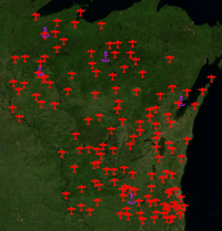
WisDOT has developed buffer rings for private and public use airports. They are based on requirements outlined in the Wisconsin Highway Department’s Facilities Development Manual.
This data provides general guidance and airport information for highway construction projects in and around Wisconsin airports. It specifically makes contractors and consultants aware of these areas, as well as providing contact information for both public and private-use airports.
| Data Format | Data Layer | Description | Metadata |
| kmz | Airport reference points (ARP) and buffers | Airport reference points and buffers with Wisconsin airport data in kmz file format for use with Google Earth or ArcGIS Explorer GIS software | metadata |
| shp | Airport reference points (ARP) and buffers | Airport reference points and buffers with Wisconsin airport data in shape file format for use with ArcGIS Explorer or ArcGIS Desktop GIS software | |
| lpk | Airport reference points (ARP) and buffers | Airport reference points and buffers with Wisconsin airport data in layer package format for use with ArcGIS Explorer or ArcGIS Desktop GIS software |
Note: Private use airports with 2 mile
buffers are only shown for airports that are listed within the FAA's
National Flight Data Center (NFDC) database. Goole Earth may
show additional airports that are not included within this set of
data. Please email Justin Hetland,
justin.hetland@dot.wi.gov or phone (608) 267-5018 for additional
information.
Questions about the content of this page:
Justin Hetland, justin.hetland@dot.wi.gov
Last modified: April 4, 2013
[an error occurred while processing this directive]